

The El Niño event developing across the equatorial Pacific could strengthen into a “super El Niño” before the end of the year, with the Hong Kong Observatory warning that the event may reach its highest intensity between November and December and potentially become the strongest recorded since 1950.
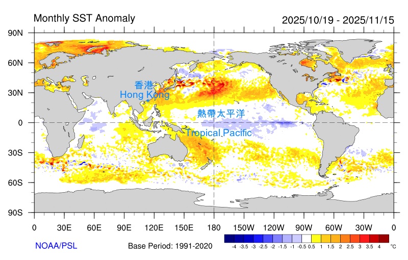
The warning comes after a sharp rise in ocean temperatures across the central and eastern equatorial Pacific. According to the Observatory’s latest weather blog, sea surface temperature anomalies in the key monitoring region rose rapidly from April and reached 2.5 degrees Celsius above average in August.
The pace of warming has already pushed the event well beyond the threshold associated with an established El Niño. Over the past five months, the cumulative sea surface temperature anomaly in the monitoring region has exceeded 4 degrees Celsius, confirming that the climate pattern is now firmly in place.
Ocean temperatures point to a powerful peak
El Niño develops when unusually warm surface waters spread across the central and eastern tropical Pacific, disrupting atmospheric circulation and influencing weather well beyond the Pacific basin.
The current event has strengthened considerably since spring. The latest figures from the Hong Kong Observatory show that the temperature anomaly in the monitored equatorial Pacific region reached positive 2.5 degrees in August.
Forecasters expect that figure to rise further in the months ahead.
The Observatory projects that the sea surface temperature anomaly could exceed 3.5 degrees Celsius between November and December. If that occurs, the event could surpass previous records and become the strongest El Niño observed since systematic records began in 1950.
That would place the current episode among the most intense El Niño events documented in modern climate records.
The forecast peak is also significant because the strongest effects of El Niño do not necessarily occur at the same time as the initial development of the phenomenon. Ocean temperatures, atmospheric circulation and tropical weather systems interact over several months, meaning conditions can continue intensifying after an El Niño has already been officially declared.
For Hong Kong and the wider Asia Pacific region, that creates a prolonged period of uncertainty as forecasters monitor how the warming Pacific affects regional weather patterns.
Event expected to last into 2027
The Hong Kong Observatory does not expect the El Niño to disappear quickly after its projected winter peak.
Instead, the current forecast indicates that the event could persist until at least spring 2027. Ocean temperatures in the main monitoring regions are expected to begin declining early next year, but the gradual cooling may not immediately bring the wider climate pattern to an end.
That distinction matters because El Niño is not determined by a single temperature reading. Its development depends on sustained ocean warming together with changes in the atmosphere above the tropical Pacific.
Even as temperatures begin to fall, the atmospheric response can continue for months.
The Observatory’s projection therefore points to an extended period in which the effects associated with the current El Niño may continue to influence weather conditions across the region.
The strength of the event will remain closely watched through the autumn and winter, particularly as sea surface temperatures approach the forecast threshold of 3.5 degrees Celsius above normal.
Record cyclone activity adds to concerns
The warning about the developing super El Niño comes against the backdrop of unusually active tropical cyclone conditions across the western North Pacific and the South China Sea.
The Hong Kong Observatory reported that 13 tropical cyclones occurred across the two regions in August. Twelve of those systems formed during the month itself.
That number broke the single month record for the period since 1961.
The figure is notable not simply because of the number of storms, but because of how quickly the systems developed within the same month. Twelve tropical cyclones forming during August represents an exceptional concentration of tropical cyclone activity in the western North Pacific and South China Sea.
The region regularly experiences numerous tropical cyclones during the summer and early autumn, but the August total exceeded the previous monthly record maintained in the Observatory’s records dating back to 1961.
For communities around the South China Sea and western Pacific, increased tropical cyclone activity can bring a combination of hazards, including destructive winds, torrential rain, storm surges and major disruption to transport.
Hong Kong is particularly exposed to tropical cyclone impacts during the summer and autumn typhoon season. Even storms that do not make a direct landfall can affect the territory through strong winds, heavy rainfall and rough seas.

A closely watched climate pattern
El Niño is one of the most important recurring climate patterns affecting the tropical Pacific. Its influence can extend far beyond the region where the warming begins, altering rainfall, temperature and storm patterns in different parts of the world.
The strength of an El Niño is commonly assessed through sea surface temperature anomalies in designated areas of the equatorial Pacific. The larger and more persistent the positive anomaly, the stronger the event is generally considered to be.
The current readings have attracted attention because of the speed and scale of the warming recorded since April.
By August, the anomaly had already reached 2.5 degrees Celsius, while the cumulative anomaly over the preceding five months exceeded 4 degrees. The Observatory now expects the warming to continue toward the end of the year before reaching a projected peak between November and December.
If the anomaly climbs beyond 3.5 degrees during that period, the event could establish a new benchmark for El Niño intensity in the observational record dating back to 1950.
What happens after the peak
A record peak in late 2026 would not necessarily mean that weather impacts end immediately afterward.
The Observatory expects ocean temperatures in the key monitoring areas to gradually decline from early 2027, but forecasts indicate that the El Niño pattern could remain in place through at least the spring.
That means the coming months will be important for monitoring both the Pacific Ocean and the atmosphere above it.
Forecasters will be watching whether the projected warming materialises, how long temperatures remain at elevated levels and whether atmospheric conditions continue to reinforce the event. They will also track tropical cyclone activity across the western North Pacific and South China Sea as the region moves through the remainder of the cyclone season.
The combination of a rapidly strengthening El Niño and the record number of tropical cyclones recorded in August has placed the region under particularly close observation.
For now, the clearest signal is in the Pacific itself: ocean temperatures have risen sharply, the El Niño event is firmly established, and the Hong Kong Observatory expects its strongest phase to arrive around November or December.
If temperatures exceed 3.5 degrees above average as forecast, the current event could move into record territory. Even after the ocean begins cooling in early 2027, the Observatory expects El Niño conditions to persist for several more months.